Shrinking Space and Expanding Population: Socioeconomic Impacts of Majuli’s Changing Geography
Understanding Riverbank Erosion in Majuli Island of India: Geomorphological Process and Policy Implications

Avijit Sahay Department of Humanities and Social Sciences, Indian Institute of Technology Bombay, Mumbai, Maharashtra, India-400076

Nikhil Roy Department of Geography, Delhi University, Delhi-110007, Delhi, India
Azizur Rahman Siddiqui Department of Geography, University of Allahabad, Allahabad-211002, U.P., India
DOI: 10.21690/foge/2020.63.8f
Riverbank erosion along the River Brahmaputra in the Majuli Island of Assam has led to the displacement of thousands of people,rendering them landless and homeless. However, those affected by riverbank erosion do not qualify for any assistance from the Central and State governments programs for natural hazard because erosion is not defined as a hazard under Indian laws. This paper argues that riverbank erosion in Assam is not a case of simple lateral erosion but a complex process involving mass migration of river channel and associated bank failure. A close look at the fluvial geomorphology of the Brahmaputra, including analysis using the Sinuosity Index and Braiding Index for the segment of Brahmaputra in the island of Majuli, suggests the process and effects counter the rationale for excluding riverbank erosion from the list of natural hazards, and provides a compelling case for re-examining, re-defining, and re-classifying hazards in India .
Introduction
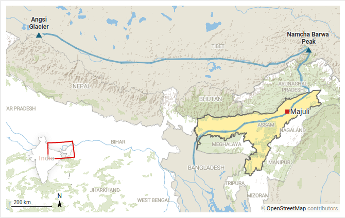
The River Brahmaputra originates from the Angsi glacier of Tibet and travels 1625 km in China as Tsangpo before entering into India through a deep gorge near the Namcha Barwa peak. In India, it flows for 918 km of which 720 km is in Assam (Goswami, 2008). The river enters the Assam plain from Pasighat in the East Siang district of Arunachal Pradesh and is joined by Rivers Dibang and Lohit in quick succession at the head of Assam valley. Further south it is joined by Himalayan Rivers such as Kemang, Manas, Subansiri etc. The entire Brahmaputra Plain in Assam of 56,000 Km2 has a gradient ranging from 0.1 m/Km near Guwahati (Saikia and Das, 2006) in the South-West to 16.8 m/Km near Pasighat in the North East (Sarkar et al., 2012).
In addition to carrying huge volumes of water and silt over a very flat plain, in 1950, Brahmaputra valley was the epicentre of an 8.7 magnitude earthquake that raised the river valley by up to 11 meters (Bilham and England, 2001) and caused severe flooding in Assam. Post-earthquake, the river has been eroding land along its banks at an alarming rate. According to the Water Resource Department (WRD, 2008) of Assam, while in 1920s, the River Brahmaputra occupied an area of 4000 Km2 in Assam; today, it occupies more than 6000 Km2.
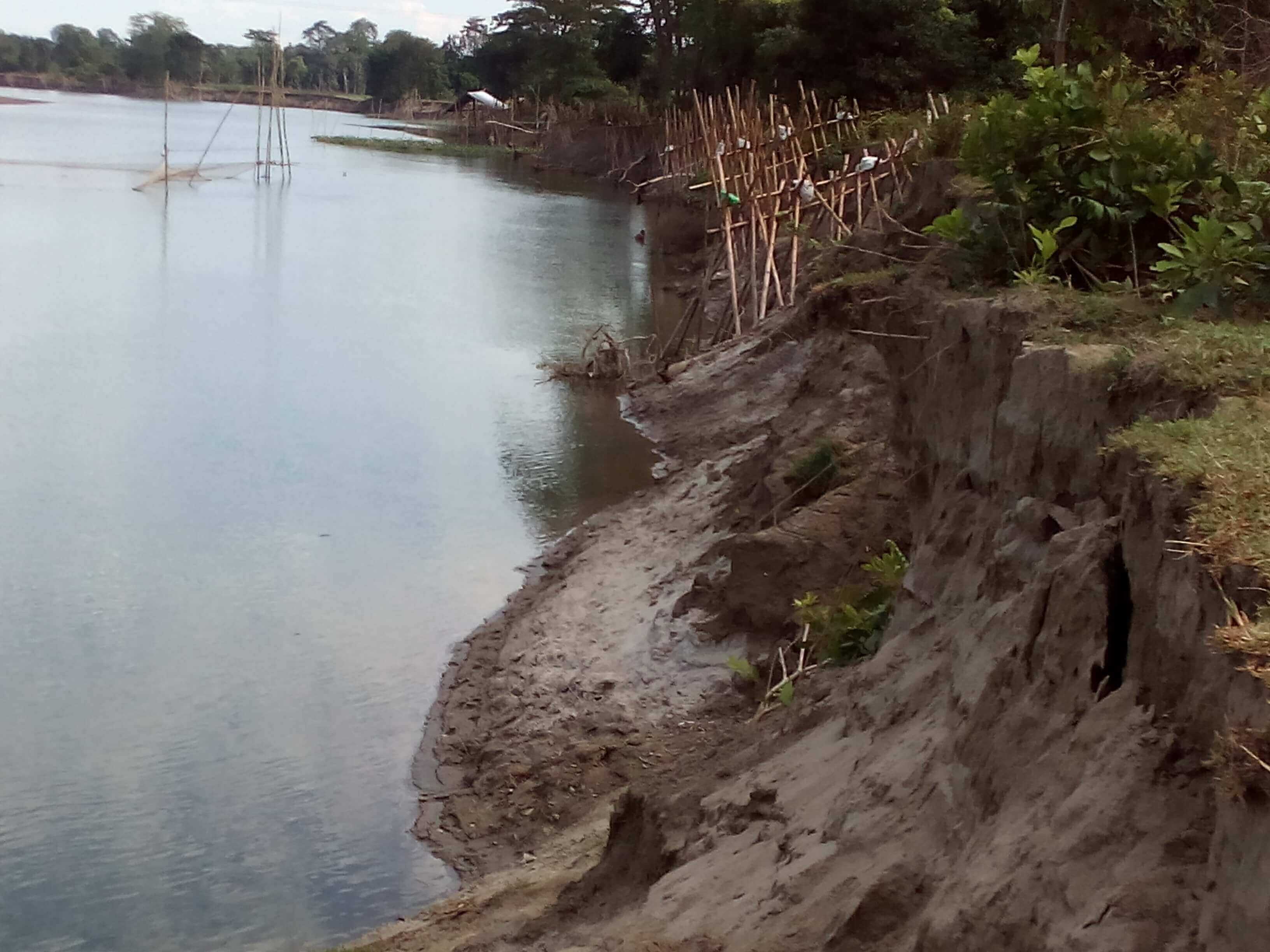
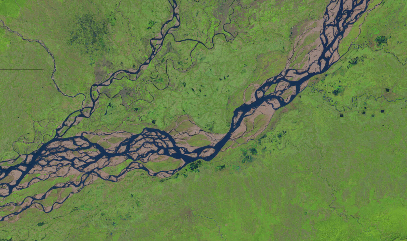
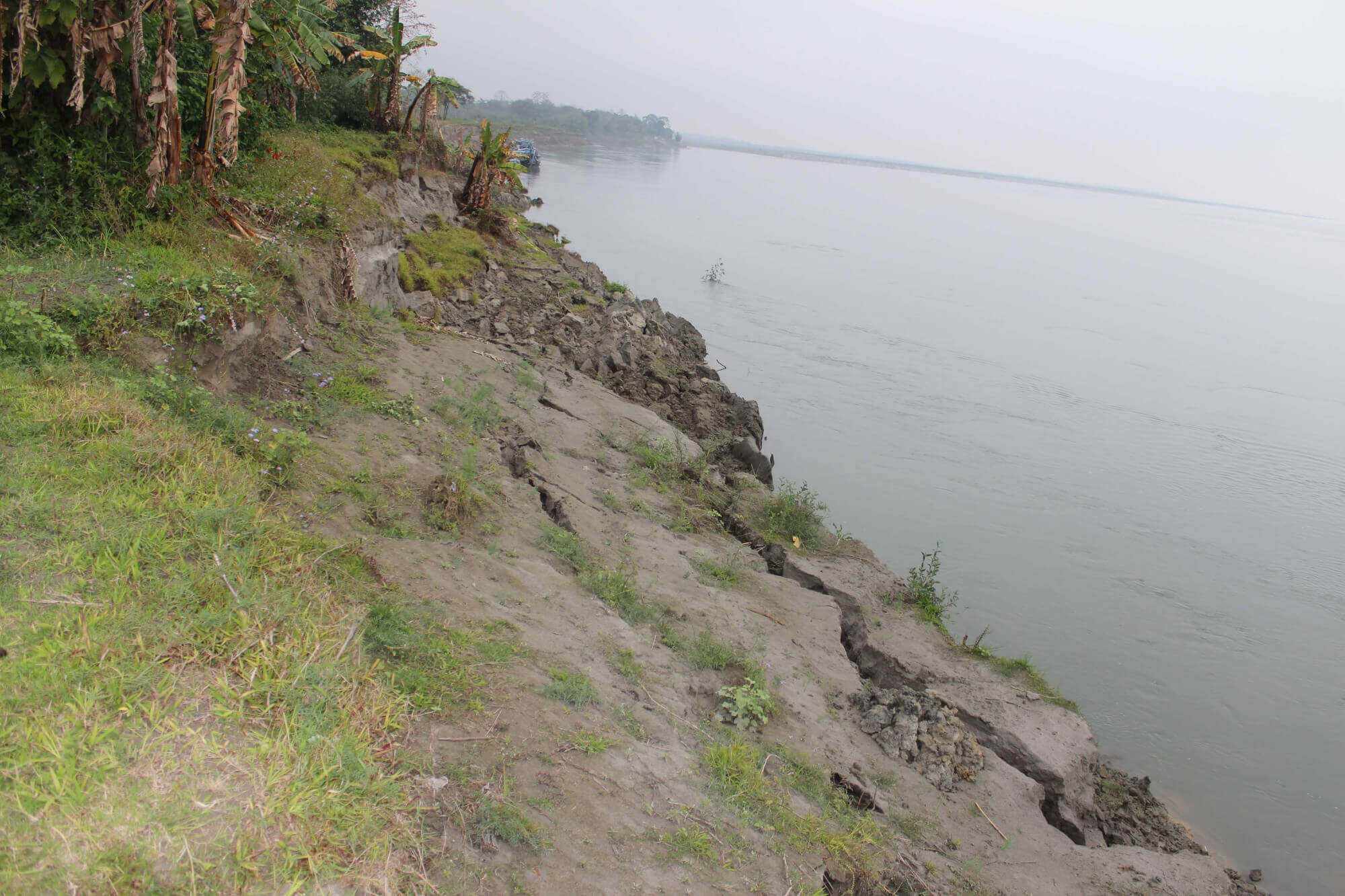
The combined effects of a large volume of water, high silt content, heavy rainfall, and unstable geology have resulted in anunsteady river channel of the Brahmaputra causing heavy lateral erosion in India and Bangladesh. Satellite images show that in the state of Assam, land has been lost at the rate of 72.5 to 80 Km2 per year from 1997 to 2008 (WRD, 2008). In an agricultural region like Assam, this loss of land has badly affected the agricultural communities of the state (picture 1). Yet, for the thousands of people affected or altogether displaced by the erosional work of the river, the current laws and policies regarding natural disasters in India do not provide any meaningful relief (Sahay, 2017). The Disaster Management Division of the Ministry of Home Affair, Government of India, provides a framework for compensating people hit by natural disasters in the form of National Disaster Response Fund (NDRF, 2010) and the State Disaster Response Fund (SDRF, 2010). In both the cases, the natural hazards that are covered are; “cyclone, drought, earthquake, fire, flood, tsunami, hailstorm, landslide, avalanche, cloud burst, pest attack, and frost and cold wave”.
The exclusion of riverbank erosion from this list means that there is no administrative or policy framework under which the people displaced because of erosion can be compensated or rehabilitated (Sahay, 2017).Thus, the classification of natural hazards in India has resulted in the marginalisation of the victims of lateral erosional work of Brahmaputra, which begs the question, is there any academic rationale behind the exclusion of riverbank erosion as a natural hazard?
Riverbank Erosion and Natural Hazards:
In a majority of works on natural hazards, there is no mention of erosion or more particularly riverbank erosion as a hazard. According to Kapur (2010), hazards affecting India include snowfall, cold waves, hailstorms, lightning, thunderstorms, squalls, dust storms, heat waves, cloudbursts, gales, cyclones, heavy rain, flood, flash flood, drought, and earthquake. Most studies consider geophysical events such as earthquakes, landslides, volcanic activities, and floods as natural hazards (Alcantara-Ayala, 2002). Geomorphological studies associate flooding (Kale et al., 1994; Baker 1994; Chowdhury, 2000), earthquake (Panizza, 1991; Ordaz and Reyes, 1999), and volcanic activities (Thouret, 1999) most commonly with disasters. The classification of hazards by Emergency Event Database (EM-DAT, 2018) also does not contain any mention of erosion or riverbank erosion. The geophysical hazards according to this classification are limited to earthquake, mass movement, and volcanic activity; while hydrological hazards are limited to floods, landslides, and wave action.
Studies concerned with damages caused by hazards also do not focus specifically on riverbank erosion. Anderson (1991) approximated damages caused by earthquakes, floods, droughts, volcanic eruptions, and hurricanes. Other studies have focused on the frequency and damage caused by earthquakes (Blaikie et al., 1994), floods, cyclones (Smith and Handmer, 1989), volcanoes (Glickman et al., 1992; Nanjira, 1991; Blaikie et al., 1994), and landslides (Blaikie et al., 1994; Petley, 1998).
It is clear from the above discussion that riverbank erosion is not identified as a hazard in most general works on hazards and disasters. Predominantly, riverbank erosion finds mention in hazard related study only when any particular case of bank erosion or bank failure is being studied. Even then, most works on bank erosion focus more on the geomorphological aspects of erosion like the process of fluvial erosion (Julian and Torres, 2006; Papanicolau, Ehakeem and Hilldale, 2007)environmental controls on erosion (Dickinson and Scott, 1979), lateral stream migration (Hickin, 1974), and bank retreat (Hooke, 1995; Gurnell, 1997) than on its merit as a hazard. In the subsequent paragraphs, an attempt has been made to study riverbank erosion as a natural hazard and its impact on human life and property.
Riverbank Erosion as a Natural Hazard:
Riverbank erosion is a significant land degradation process (Hughes and Prosser, 2003). Odgaard (1987) identifies riverbank erosion as a hazard and a resource management problem of global sequence. Bank erosion is a significant problem to people who derive income from, or live on land next to rivers (Atkinson et al., 2003) because infrastructure located along riverbank is threatened by accelerated bank erosion and land loss (Darnby and Thorne, 1994). Most badly hit are communities that depend directly or indirectly on agriculture for sustenance. This is why the lateral erosional work of the Brahmaputra has become such a significant problem in India and Bangladesh. The agrarian economy of these countries means that the effect of bank erosion on the larger society is disproportionate. In the Indian state of Assam, the damages to crops, cattle, houses, and utilities between 1953 to 1995 have been estimated at Rs 440 million (Goyari, 2005), and almost 7.4% of the land area of the state has been lost to the river (Phukan et al., 2012).
If by definition, a natural hazard is loss of life or property from physical and environmental causes(Middleman and Middleman, 2007; Mayhew, 2015),then by this definition, riverbank erosion should qualify and be mentioned as such in all academic works on hazards. However, this is not the case, and the reason for this is that firstly erosion is a slow process while hazards are sudden events (Alexander, 1993) and also because of the limited and localized nature of the threat perception of riverbank erosion. Floods (30%), hurricanes and cyclones (20%), earthquake (15% to 17%), and tornadoes (12%) are the most frequent and common hazard events (Tobin and Montz, 1997). Similarly, in terms of deaths, earthquakes, cyclones, and floods respectively cause the most casualties (Glickman et al., 1992; Tobin and Montz, 1997). On the other hand, bank erosion is a major problem mainly in Iowa river basins in the USA (Odgaard, 1987), Gordon and Murray-Darling basin in Australia (Hughes and Prosser, 2003), and Brahmaputra in India and Bangladesh (Haque and Zaman, 1989; Kotoky et al., 2005; Rahman, 2010; Sahay and Roy, 2017).
While it is difficult to compare the suddenness of riverbank erosion in the Brahmaputra river basin in Majuli with the suddenness of natural events that are universally considered as hazards, an indirect attempt can be made. According to Kotoky et al. (2003), the River Brahmaputra has eroded land in Majuli Island at a rate of 1.2 Km2 per year over a nearly 70 year period. In another study, Kalita (2016) has estimated that the rate of riverbank erosion is increasing and is now around 6.42 Km2 per year. The rate of erosion can also be measured in terms of the number of families displaced because of riverbank erosion and is given in Table 1.
| Year | Number of families affected by erosion |
|---|---|
| 2000 | 567 |
| 2001 | 63 |
| 2002 | 204 |
| 2003 | 100 |
| 2004 | 401 |
| 2005 | 471 |
| 2006 | 150 |
| 2007 | 564 |
| 2008 | 185 |
| 2009 | 52 |
| 2010 | 329 |
| 2011 | 132 |
| 2012 | 321 |
| Total | 3539 |
Riverbank erosion occurs only along the banks of Brahmaputra but still affects on an average around 300 families every year. In contrast floods, which has a much wider spread and covers all areas of Majuli, displaces around 500 families on years of normal flooding (Government of Assam, 2014). Moreover, those displaced by flood can return to their original land once flood water recedes, but those displaced by riverbank erosion lose their land permanently and have to be resettled. Thus, riverbank erosion in Majuli is comparable to other sudden events like floods and in the subsequent paragraphs, we will try to show how complex and sudden it is and what causes this suddenness.
Geomorphological Processes in Riverbank Erosion:
Erosional work of rivers is of three types-vertical, headward, and lateral (Easterbrook, 1999).Vertical erosion leads to valley deepening, headward erosion makes river channel longer (valley lengthening) and lateral erosion makes riverbanks wider (valley broadening). Riverbank erosion is generally associated with the lateral erosional work of rivers. In lateral erosion, the bank of a river is divided into three classes-toe zone, bank zone and overbank zone(Biedenharn et al, 1999; Hoag and Landis, 2001) based on the intensity and frequency of erosion.
The Toe Zone is the part of the bank that lies between the high water level and the low water level. Bank Zone is the part that lies between the high water level and the areas that are inundated in normal floods. The Overbank Zone is that part of the bank that is subject to erosion and flooding in the most extreme cases of floods only, and in normal years, it remains as a refuge against the approaching river.
Lateral erosion of riverbanks is a natural process, and only affects the toe zone and thereby leads to broadening of the valley. However, in the years of floods, the advancing riverbank cuts through the bank zone and cause erosion in this area too. Overbank zone, on the other hand, is only rarely subjected to the erosional work of river, and is therefore, ideal place for settlements and agriculture.
If the erosional work of the river extends frequently to the bank zone and overbank zone, then the process is called mass failure(Rinaldi and Darby, 2008) and is responsible for most of the instances of riverbank erosion (Lawler, 1993; Couper and Maddock, 2001; Simon and Collison, 2002; Rinaldi and Darby, 2008). However, in this work, we argue that fluvial geometry of the River Brahmaputra and not simply mass failure is the chief cause of erosion and the associated calamities in India and Bangladesh.
Fluvial Geometry:
The two most dominant river channel patterns are meandering and braided river(Leopold and Wolman, 1957). Meandering rivers flow through a sinuous path (Friend and Sinha, 1993) without the formation of mid channel bars and river islands (Flis, 2011). Braided rivers on the other hand are characterised by mid channel bars and have low sinuosity (van der Berg, 1994). The controlling factors that determine the pattern of a river are water discharge, slope, and size and types of particles that are carried by the river (Bridge, 2003). Thus, rivers that have greater water discharge, relatively steep slope, and coarse particles tend to be braided, while rivers flowing through gentler slope, having less discharge, and finer particles make river meanders (Bridge, 2003).
To calculate the degree of meander, the Sinuosity Index is used. The Sinuosity Index is a ratio of the length of the stream to the length of the valley (Leopold and Wolman, 1957), and is expressed as:
In a completely straight river, the Sinuosity Index will be 1 as both the Stream Length as well as Valley Length will be same. However, all rivers have at least some bend in their course and therefore, all rivers have Stream Length that is greater than Valley Length, which leads to a Sinuosity Index always greater than 1. Leopold and Wolman (1957) gave the scheme for classification of rivers on the basis of Sinuosity Index (S.I.) as Straight River if S.I. is 1.1 to 1.5, and Meandering River if S.I. is greater than 1.5.
Calculation of parameters of braiding is more complex than sinuosity and is called the Braiding Index (B.I.). B.I. can be calculated from the length of islands of the sand bars and islands (Brice, 1964) or from the length of all the streams of the braided river (Rust 1978; Friend and Sinha, 1993). For this study, we use the formula of Friend and Sinha (1993), which measured Braiding Index as the ratio between the total lengths of channels of all the streams to the length of the primary channel, and is expressed as:
Riverbank Erosion in Brahmaputra:
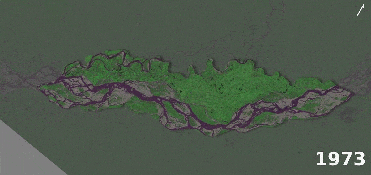
To understand the various factors that lead to unstable nature of the river channel and its changing course, a 95 Km section of Brahmaputra, through the river island of Majuli has been digitised from Landsat Images of 1975, 2000, and 2015. The three images are shown below as Figures 1, 2, and 3.
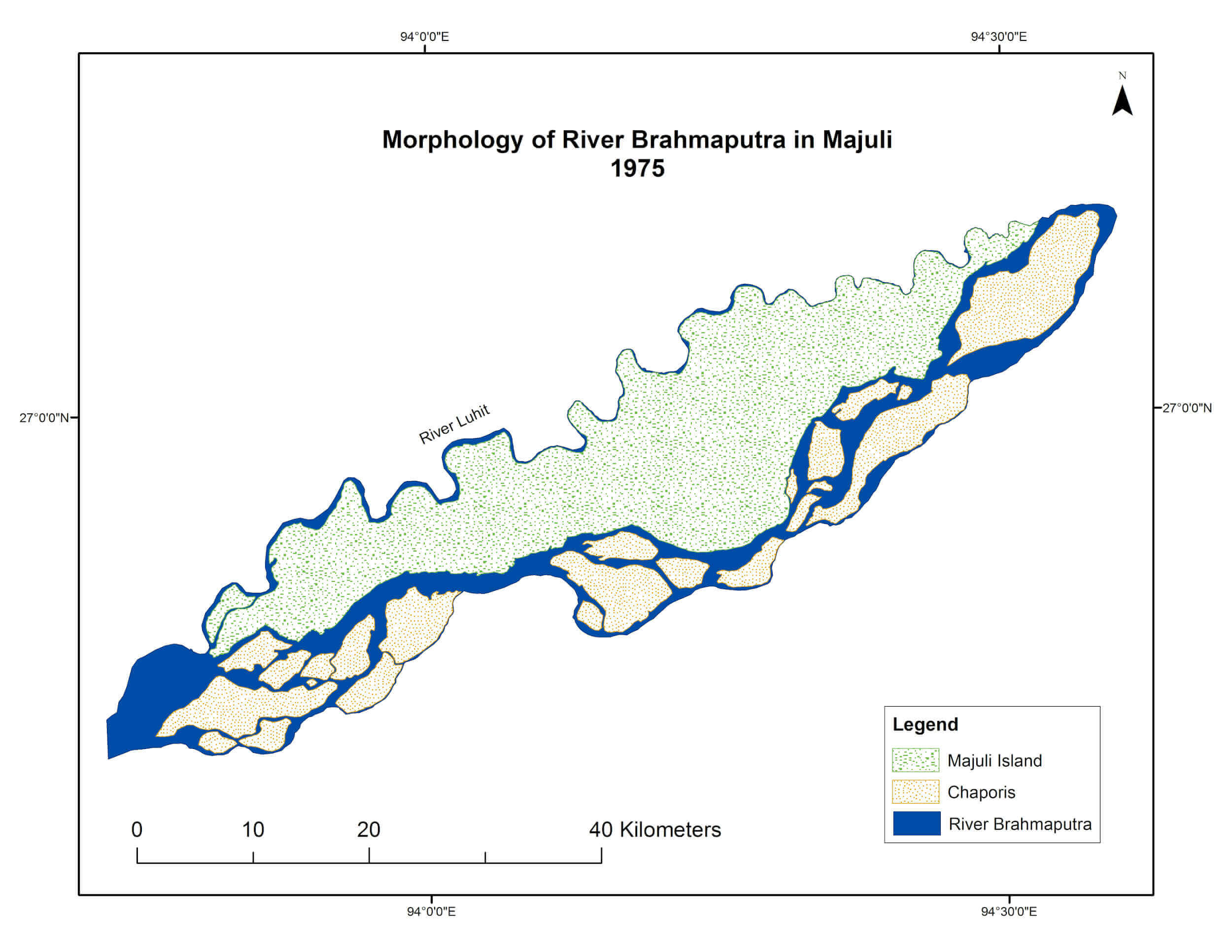
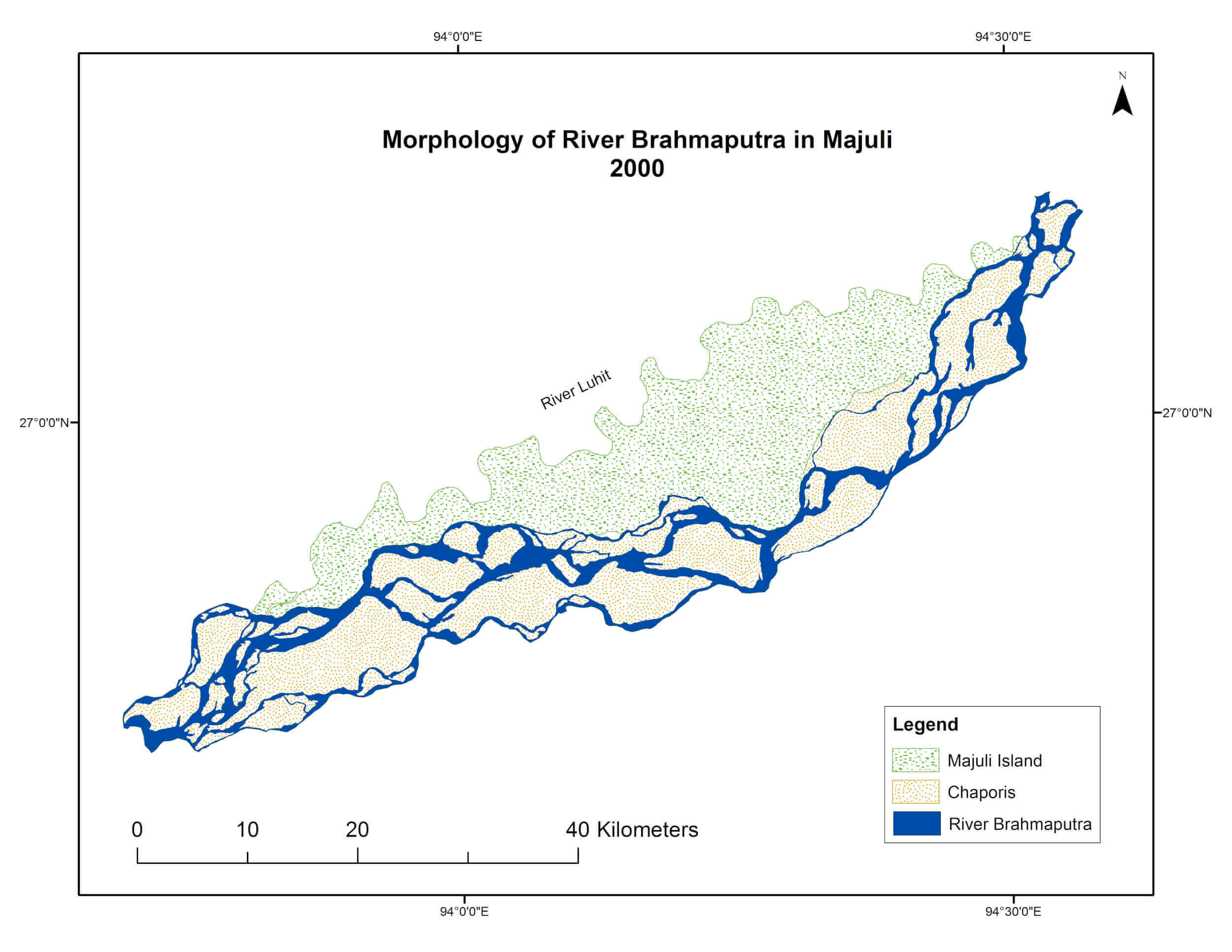
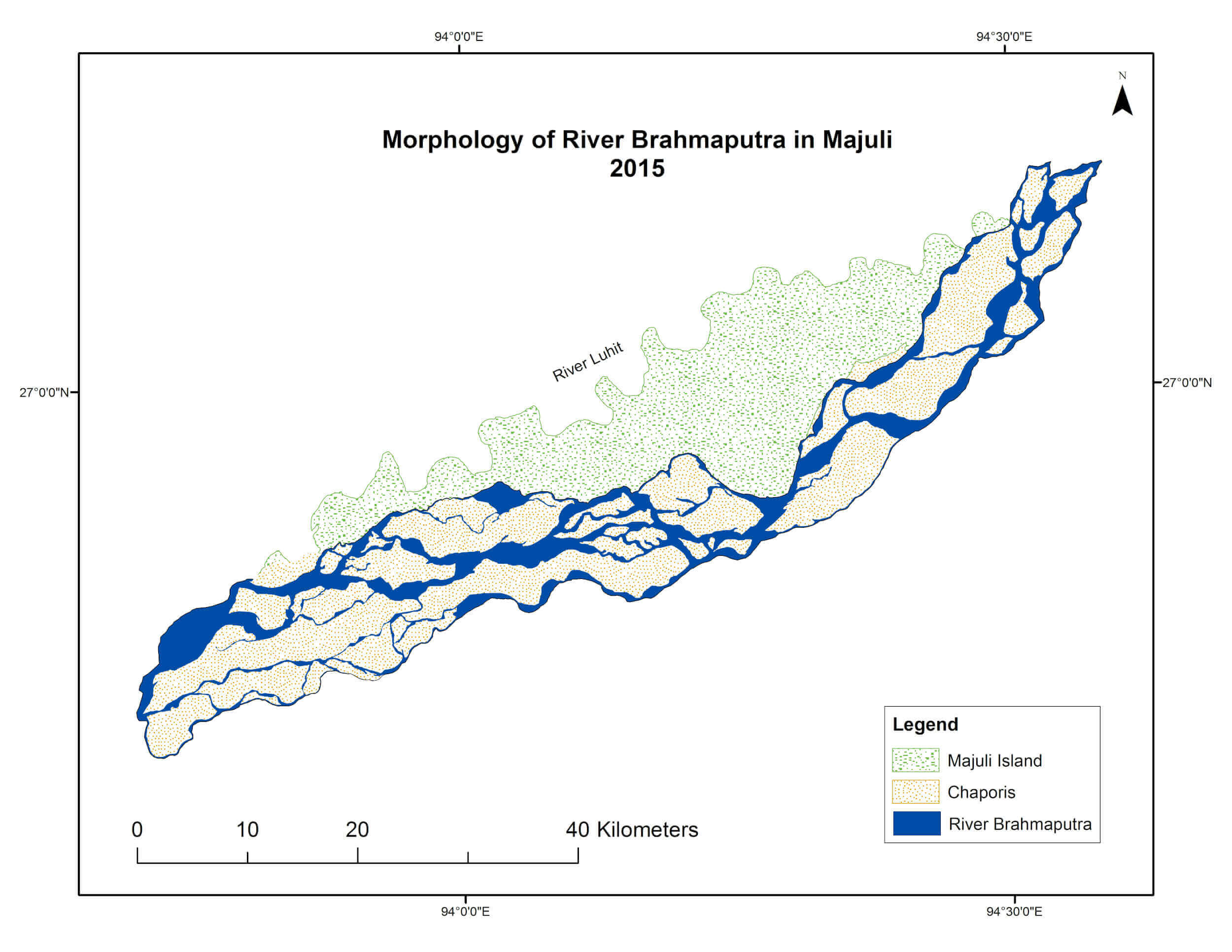
Based on these three images, and the fluvial geometry of Brahmaputra, profile of the segment of Brahmaputra in Majuli Island has been analysed in this work.
Profile of Brahmaputra:
Brahmaputra descends from a height of 2450 meters above sea level in Himalayan regions to 135 meters above sea level at Sadiya in the Assam plain within a stretch of a few kilometres. As soon as it reaches the plains, it is joined by Dibang in the north and Lohit in the south. The abrupt change in elevation, coupled with high water and silt content has led to frequent floods and lateral erosion in the river (Goswami, 2008). A high water discharge of more than 2.5 million cusecs of water during flood (Coleman, 1969), and presence of coarse sediments from its upper channel (Coleman, 1969) means that, the Brahmaputra in India is an extensively braided river with multiple channels turning around numerous mid-channel and lateral sandbars, locally known as ‘Chars’ (Goswami, 2008). A braided river is a special type of river channel in which many small streams separate from the main river, travel for some distance and then rejoin the main river channel. A braided river thus appears to be several streams separated by small midchannel bars of islands that are often temporary and are called ‘chars’ or ‘chapooris’ in Assam.
| Year | Braiding Index (B.I.) |
|---|---|
| 1975 | 4.30 |
| 2000 | 4.94 |
| 2000 | 5.35 |
However, from the satellite images (Figures 1, 2, and 3) of Brahmaputra, an increase in sinuosity of the river from 1975 to 2015 is discernible. In simple terms, sinuosity is the measure of twists and turns that a river goes through in its course. As explained above, no river follows a completely straight path and there is therefore, some amount of meandering in any river. To calculate the degree to which the River Brahmaputra meanders, and an increase in its sinuosity if any, Sinuosity Index from equation (1) above has also been calculated for the years 1975, 2000, and 2015 and are given in Table 3.
| Year | Braiding Index (B.I.) |
|---|---|
| 1975 | 1.17 |
| 2000 | 1.27 |
| 2000 | 1.32 |
From the table above, as well as satellite images, it is evident that the sinuosity of the Brahmaputra is increasing. Even though it is still not a meandering river according to the scheme of Leopold and Wolman (1957), it is at least now meandering more than it did in 1975, and this degree of meander is increasing continuously. Thus, the Brahmaputra which has always been a braided river is now also becoming a meandering river.
This new trend of increasing sinuosity of the Brahmaputra can be attributed to the powerful earthquakes of 1897 and 1950 (Goswami, 2008) that disturbed the geology of the river channel and drastically affected the gradient of this river (Bilham and England, 2001; Rajendran et al., 2004; Devi and Bora, 2016), stopping the flow temporarily and bringing about flooding and rapid accumulation of enormous volume of sediment in the channel (Valdiya, 1999). Post earthquake, the river has been eroding land at an alarming rate (WRD, 2008), and the speed as well as force of erosion cannot be explained by the processes of mass failure alone.
The earthquake of 1950 caused siltation up to 2.5 to 3 m (Valdiya, 1999) in many parts of the valley,while the earthquake of 1897 uplifted the Shillong Plateau (Bilham and England, 2001; Baro and Kumar, 2015), as well as the segment of Brahmaputra Valley near Guwahati, which lies at the foot of Shillong Plateau (Baro and Kumar, 2015). The current gradient of Brahmaputra near Guwahati is barely 0.1 m/Km (Sarkar et al., 2011) and the average gradient in the entire length of Brahmaputra in Assam is only 0.13 m/Km (Saikia and Das, 2006). This low gradient (Singh, 2007) has caused the Brahmaputra to increase its sinuosity.
The effect of increasing sinuosity of a river in its braided profile has been mass migration of the river and large scale channel widening. In Figure 1, the morphology of Brahmaputra through the island of Majuli in 1975 is shown.
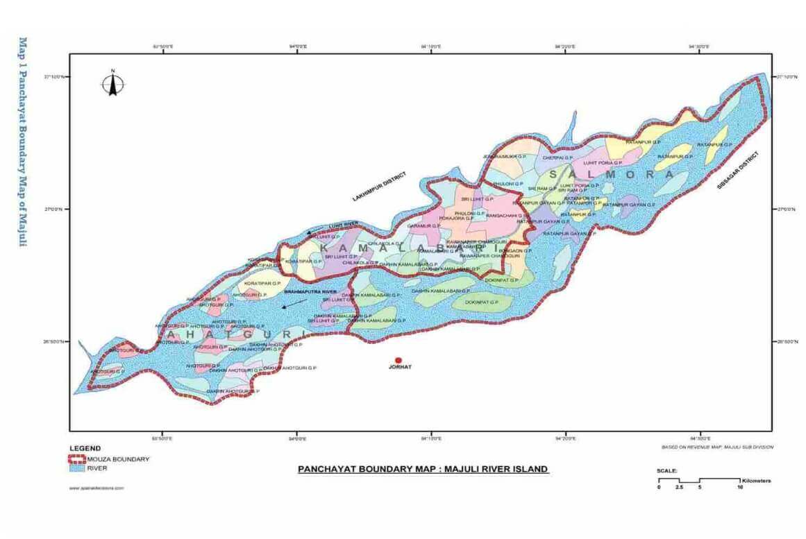
Majuli island is divided into three mauzas (traditional administrative divisions of East India)-Ahatguri in the west, Kamlabari in the centre and Salmora in the east (Figure 4).
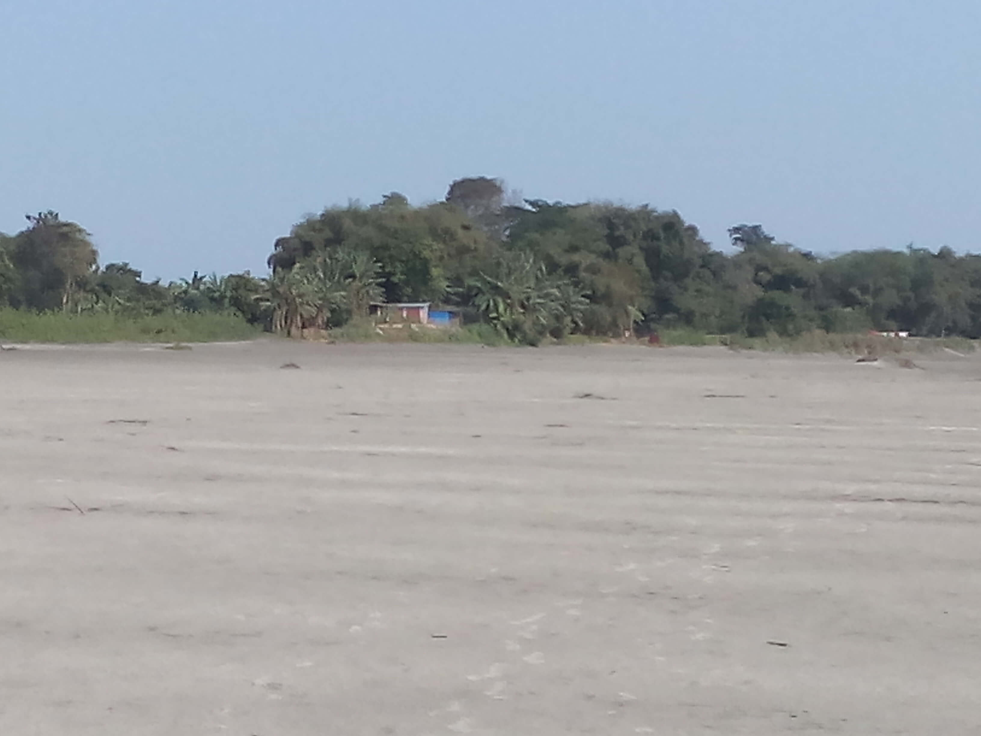
From 1975 to 2000, Brahmaputra has perceptibly migrated to the north in the south west section of the island (see Figure 2). However, in the north and north east, there has been no major change in the morphology of the river. Because of the northward migration of the river in the south-west part of the island, large areas of the administrative division of Ahatguri have been lost to the river (picture 2). The people living in these parts have been relocated to other areas in Majuli, or resettled entirely out of the island.
By 2015 (see Figure 3), the northward migration of the Brahmaputra in the southwest section has been complete. This has led to the almost total wipe out of Ahatguri, as well as a number of villages in Kamlabari. However, of even greater significance is the new northward shift noticed in the north-eastern parts (Salmora administrative division) of the island. This shift in Salmora is now threatening totally new areas with consequences of riverbank erosion.
Thus, the unstable morphology of Brahmaputra means that riverbank erosion here cannot be explained by the processes of mass failure alone.
Channel Migration and Riverbank Erosion in Brahmaputra:
The increase in sinuosity in a braided river means that all the different streams that make the River Brahmaputra in Assam are changing their course continuously and thereby eroding new areas each year. This process causes continuous migration in river channel that leads to constant erosion and is called channel migration (picture 3).
Channel Migration can thus, be defined as the intensity with which a braided river with a meandering course will migrate from its original channel and thereby increase the width of its channel in a given time interval. From the discussions above, it is clear that channel migration is a function of high Sinuosity Index (S.I.) and high Braiding Index (B.I.) of a river and can therefore, be expressed as:
The process of channel migration is not restricted to Majuli as mass failure is taking place throughout the 720 Km length of the Brahmaputra in Assam. Between 1912 and 1996, approximately 868 Km2 of land in Assam was lost to the river (Sarma, 2005). Such loss of land in a region that is entirely dependent on agriculture means economic catastrophe for the population (Goyari, 2005).
Sarma and Phukan (2006) have further calculated net maximum shift of Brahmaputra in the period 1912-1996 as 7740 m in north bank towards north, 8754 m in the north bank towards south, 7090 m in the south bank towards south, and 6375 m in the south bank towards north. The shift in both directions in the north as well as south banks of the river points to a steady widening of the river channel. This is corroborated by our analysis of fluvial geometry which shows the increase in sinuosity of the River Brahmaputra in the Majuli segment from 1975 to 2015.
Policy Implications:
In Majuli, riverbank erosion has caused total or partial wipe out of more than half of the total cadastral villages (107 out of 210). According to estimates, at least one-third of the total population of Majuli (167,304 persons in Census, 2011) is affected by erosion, with many having been rendered landless and homeless. This process has occurred across the entire 720 Km length of the Brahmaputra in Assam. In an 11 year period from 1997 to 2008 alone, riverbank erosion has wiped out more than 2500 villages and 18 towns, and displaced nearly 500,000 persons (WRD, 2008). Thus, there are huge human and economic costs of erosion in River Brahmaputra. Moreover, riverbank erosion in Majuli is affecting the most vulnerable sections of Assamese society. The average monthly income in Assam is close to Rs 7000 equivalent to US$100 (RBI, 2019) and Majuli is one of the poorer regions of Assam. According to 2011 census, the entire population of Majuli is rural and depends on agriculture and fisheries for income. However, riverbank erosion has a detrimental effect on both these sources of livelihood and has thus, has severely compromised the ability of population to adapt to it. Also, disaster management efforts in India do not recognise riverbank erosion as natural or environmental hazard and therefore, no relief is provided to those affected by erosion under disaster management laws. There is an understanding that riverbank erosion in River Brahmaputra is a form of lateral erosion and is therefore a slow process. In the absence of any national or state level policy to tackle riverbank erosion, the District Administration of Majuli has been trying to resettle the uprooted families in areas in and around Majuli. According to the data collected from the Revenue Circle office of Majuli during fieldwork, a total 10,233 families had been resettled till July 29, 2014. However, in an island, in which about 250 or more families are being uprooted every year for the past more than 65 years, this is definitely not adequate (Sahay 2017). To provide long term relief to those uprooted because of riverbank erosion, disaster management laws in India must consider it as a natural hazard. Our analysis shows that riverbank erosion is caused by channel migration because of increasing sinuosity in a braided river and is a fast and sudden process. As a conclusion, it can be said that in the light of the mounting literature on the damages caused by riverbank erosion, and the analysis of riverbank erosion provided in this paper, the continued exclusion of riverbank erosion from academic discussions on natural hazards and the disaster management policies of the government in India seems unjustifiable.
References:
- Alcantara-Ayala, I. (2002). Geomorphology, Natural Hazards, Vulnerability and Prevention of Natural Disasters in Developing Countries.Geomorphology. 47(2), 107-124.
- Alexander, D., 1993. Natural Disasters. New York: UCL Press and Chapman & Hall.
- Anderson, M.B. (1991). Which Costs More: Prevention or Recovery. Managing Natural Disasters and the Environment. Washington, DC: World Bank.
- Atkinson, P.M. et al. (2003). Exploring the Relations between Riverbank Erosion and Geomorphological Controls Using Geographically Weighted Logistic Regression. Geographical Analysis. 35(1), 58-82.
- Baker, V.R. (1994). Geomorphological Understanding of Floods.Geomorphology. 10(1), 139-156.
- Baro, O. & Kumar, A. (2015). A Review of Tectonic Setting and Seismic Activity of the Shillong Plateau in the Light of Past Studies.Disaster Advances. 8(7), 34-45
- Biedenharn, D. S., Elliott, C. M., & Watson, C. C. (1997). The WES stream investigation and streambank stabilization handbook (p. 460). US Army Engineer Waterways Experiment Station.
- Blaikie, P. et al. (1994). At Risk: Natural Hazards, People’s Vulnerability, and Disasters. London: Routledge.
- Brice, J.E. (1964). Channel Patterns and Terraces of Loup Rivers in Nebraska. United States Geological Survey Professional Papers, 422-D
- Bridge, J., 2003. Rivers and Floodplains: Forms, Process and Sedimentary Record. New Jersey: Blackwell Publishing Company
- Census of India (2011). Basic Population Data
- Chowdhuri, M.R. (2000). An Assessment of Flood Forcasting in Bangladesh: The Experience of 1998 Flood. Natural Hazards. 22(2), 139-163.
- Coleman, J. M. (1969). Brahmaputra River: channel processes and sedimentation. Sedimentary Geology, 3(2-3), 129-239
- Couper, P. R., & Maddock, I. P. (2001). Subaerial river bank erosion processes and their interaction with other bank erosion mechanisms on the River Arrow, Warwickshire, UK. Earth Surface Processes and Landforms: The Journal of the British Geomorphological Research Group, 26(6), 631-646.
- Darby, S.E. & Thorne, C.R. (1994). Prediction of Tension Cracks Location and Riverbank Erosion Hazards Along Destabalized Channels.Earth Surface Process and Landforms. 19(3), 233-245.
- Devi, R. M., & Bora, P. K. (2016). The Impact of the Great 1950 Assam Earthquake on the Frontal Regions of the Northeast Himalaya. In S. D’Amico (Ed.) Earthquakes and Their Impact on Society (pp. 475-489). Cham, Switzerland: Springer.
- Dickinson, W.T. & Scott, A.M. (1979). Analysis of Streambank Erosion Variables.Canadian Agricultural Engineering. 21(1), 19-25.
- Easterbrook, D. J. (1999). Surface processes and landforms. New Jersey: Pearson College Division.
- EM-DAT (2018): The CRED/OFDA International Disaster Database – www.emdat.be – UniversiteCatholique de Louvain – Brussels – Belgium. Flis, M. (2011). Discriminating between meandering and braided rivers using a physical model: The Emriver Process Simulator (Doctoral dissertation, Wittenberg University).
- Friend, P.F &Sinha, R. (1993). Braiding and Meandering Parameters. Geological Society, London, Special Publication. 75(1), 105-111.
- Glickman, T.S. et al. (1992). Acts of God and Acts of Man: Recent Trends in Natural Disasters and Major Industrial Accidents. Washington, DC: Centre for Risk Management, Resources for the Future.
- Goswami, D. (2008). Managing the Wealth and Woes of the River Brahmaputra. Retrieved from www.indianfolklore.org/journals/index.php/Ish/article/download/449/514.
- Government of Assam (2014).Disaster Management Plan for the Sub-division of Majuli. Majuli: Sub-divisional Office
- Goyari, P. (2005). Flood Damages and Sustainability in Agriculture in Assam. Economic and Political Weekly. 40(26), 2723-2729
- Gurnell, A.M. (1997). Channel Change on the River Dee Meander, 1946-1992, from the Analysis of Air Photographs. Regulated Rivers: Research and Management. 13(1), 13-26.
- Haque, C. E., & Zaman, M. Q. (1989). Coping with riverbank erosion hazard and displacement in Bangladesh: Survival strategies and adjustments. Disasters, 13(4), 300-314.
- Hickin, E.J. (1974). The Development of Meanders in Natural River Channels.American Journal of Science.274(4). 414-442.
- Hoag, J. C., & Landis, T. D. (2001). Riparian zone restoration: field requirements and nursery opportunities. Native Plants Journal, 2(1), 30-35.
- Hooke, J.M. (1995). Process of Planform Change on Meandering River Channels in the UK.Changing River Channel, edited by A.M. Gurnell and G.E. Petts, 87-105. Chichester: John Wiley and Sons.
- Hughes, A.O. & Prosser, I.P. (2003). Gully and Riverbank Erosion Mapping for Murray-Darling Basin.Technical Report 3/03. Canberra: CSIRO Land and Water.
- Julian, J. P., & Torres, R. (2006). Hydraulic erosion of cohesive riverbanks. Geomorphology, 76(1-2), 193-206.
- Kale, V.S. et al. (1994).Geomorphic and Hydrologic Aspects of Monsoon Floods on the Narmada and Tapi Rivers in Central India.Geomorphology. 10(1), 157-168
- Kalita, D.J. (2016). Impact of Flood and Riverbank Erosion in Majuli, Assam (India) and its Restoration Measures.Dimorian Review 3(5): 21-30
- Kapur, A. (2008). Vulnerable India: A Geographical Study of Disasters. New Delhi: SAGE Publications India
- Kotoky, P., Bezbaruah, D., Baruah, J., & Sarma, J. N. (2003). Erosion Activity on Majuli: The Largest River Island of the World. Current science 84(7), 634-640.
- Kotoky, P., Bezbaruah, D., Baruah, J., & Sarma, J. N. (2005). Nature of bank erosion along the Brahmaputra river channel, Assam, India. Current science 88(4),929-932.
- Lawler, D. M. (1993). The measurement of river bank erosion and lateral channel change: a review. Earth surface processes and landforms, 18(9), 777-821.
- Leopold, L.B. & Wolman, M.G. (1957). River Channel Patterns: Braided, Meandering and Straight. U.S. Geological Survey Professional Paper, 282-B.
- Mayhew, S. (2015). A dictionary of geography. Oxford University Press, USA.
- Middlemann, M. H., & Middelmann, M. (2007). Natural hazards in Australia: identifying risk analysis requirements. Geoscience Australia.
- Nanjira, D. (1991). Disasters and Development in East Africa.Managing Natural Disasters and the Environment. Washington, DC: World Bank.
- NDRF (2010). Guidelines for National Disaster Response Fund. Retrieved from http://www.ndmindia.nic.in/images/NDRFSDRF_06042017.pdf on December 18, 2018 at 10:46 pm
- Odgaard, A.J. (1987). Streambank Erosion along two Rivers in Iowa. Water Resources Research. 23(7), 1225-1236.
- Ordaz, M. & Reyes, C. (1999). Earthquake Hazards in Mexico City: Observations versus Computations. Bulletin-Seismological Society of America. 89(5), 1379-1383.
- Papanicolaou, A. N., Elhakeem, M., & Hilldale, R. (2007). Secondary current effects on cohesive river bank erosion. Water Resources Research, 43(12).
- Petley, D.N. (1998). Geomorphological Mapping for Hazard Assessment in a Neotectonic Terrain.Geographical Journal. 164 (7), 183-201
- Panizza, M. (1991). Geomorphology and Seismic Risk.Earth-Science Reviews. 31(1), 11-20.
- Phukan, A. et al. (2012). Riverbank Erosion and Restoration in the Brahmaputra River in India. The Clarion. 1(1), 1-7.
- Rahman, M. R. (2010). Impact of riverbank erosion hazard in the Jamuna floodplain areas in Bangladesh. Journal of Science Foundation, 8(1-2), 55-65.
- Rajendran, C. P., Rajendran, K., Duarah, B. P., Baruah, S., & Earnest, A. (2004). Interpreting the style of faulting and paleoseismicity associated with the 1897 Shillong, northeast India, earthquake: Implications for regional tectonism. Tectonics, 23(4).
- RBI (2019). Per Capita Net State Domestic Product. Reserve Bank of India. Retrieved from https://www.rbi.org.in/Scripts/PublicationsView.aspx?id=19000
- Rinaldi, M., & Darby, S. E. (2007). 9 Modelling river-bank-erosion processes and mass failure mechanisms: progress towards fully coupled simulations. Developments in Earth Surface Processes, 11, 213-239.
- Rust, B.R. (1978).A Classification of Alluvial Channel Systems.Canadian Society of petroleum Geologists. 5, 187-198
- Sahay, A. (2017). Majuli and the Tragedy of Hazard Identification. Economic and Political Weekly,52(31), 26-27
- Sahay, A., & Roy, N. (2017). Shrinking Space and Expanding Population: Socioeconomic Impacts of Majuli’s Changing Geography. Focus On Geography, 60
- Saikia, B., & Das, P. (2006). Steamer Ghats (Ferry Ghats) Of Brahmaputra River: Impact on Region's Economy and Environment. In S. Sengupta et al. (Ed.) Rivers and Riverine Landscape in North East India. New Delhi: Concept Publishing House
- Sarkar, A., Garg, R. D., & Sharma, N. (2012). RS-GIS based assessment of river dynamics of Brahmaputra River in India. Journal of Water Resource and Protection, 4(02), 63-72.
- Sarma, J. N. (2005). Fluvial process and morphology of the Brahmaputra River in Assam, India.Geomorphology. 70(3-4), 226-256.
- Sarma, J.N. &Phukan, M.K. (2006). Bank Erosion and Bankline Migration of the Brahmaputra River in Assam During the Twentieth Century. Journal-Geological Society of India. 68(6), 1023-1036.
- SDRF (2010). Guidelines for State Disaster Response Fund. Retrieved from https://doe.gov.in/sites/default/files/Guidelines for State Disaster Response Fund (SDRF).pdf on December 18, 2018 at 10:47 pm
- Simon, A., & Collison, A. J. (2002). Quantifying the mechanical and hydrologic effects of riparian vegetation on streambank stability. Earth Surface Processes and Landforms, 27(5), 527-546.
- Singh, S. K. (2007). Erosion and weathering in the Brahmaputra River system. Large Rivers: Geomorphology and Management, 373-393. John Wiley & Sons
- Smith, D.I. &Handmer, J.W. (1989). Flood Insurance and Relief in Australia: The Background. Flood Insurance and Relief in Australia, Centre for Resource and Environmental Studies, Australian National University, Canberra
- Thouret, J.C. (1999). Urban Hazards and Risks; Consequences of Earthquakes and Volcanic Eruptions: An Introduction. GeoJournal. 49(2), 131-135.
- Tobin, G.A. &Montz, B.E. (1997). Natural Hazards: Explanation and Integration. New York: The Guilford Press.
- Valdiya, K.S. (1999). Why does River Brahmaputra Remain Untamed. Current Science. 76(10), 1301-1305.
- Van der Berg, J.H. (1995). Prediction of Alluvial Channel Pattern of Perennial Rivers.Geomorphology. 12(4), 259-279.
- WRD (2008).North Eastern Integrated Flood and Riverbank Erosion Management Project: Feasibility Study (PPTA, Phase II).Unpublished report of Water Resources Department.