Hurricane Dorian and Landscapes of Recovery in the Bahamas
Jordan R. Cissell, Department of
Geography and Sociology, Samford University
DOI: 10.21690/foge/2021.64.2p
Introduction
Hurricane Dorian made landfall on the Abaco Islands and Grand Bahama Island of the Bahamas between
September 1 and September 3, 2019. This three-day storm event is now recognized as one of the most
destructive natural disasters in Bahamian history, with at least 70 confirmed deaths, more than 200
people unaccounted for, and more than $3.4 billion USD in property damages (Zegarra et al. 2020).
Just as Dorian destroyed human life and property on Abaco and Grand Bahama, it also devastated the
islands’ coastal ecosystems, particularly its mangrove forests. The livelihoods of many Bahamian
communities are closely tethered to the health of these coastal ecosystems, particularly through
food from subsistence fishing; income from commercial fishing; and income from recreational fishing,
diving and snorkeling, and other tourist activities. Therefore, the ongoing recoveries of these
people and landscapes are intimately and reciprocally linked.
In February 2020, Michael Steinberg and I conducted field work on Grand Bahama as part of an ongoing
effort to map Dorian’s impacts on mangrove and pine forests on Grand Bahama and Abaco using
high-resolution satellite imagery. While the “bird’s eye view” of satellite imagery is useful for
accurately and efficiently mapping the extent of the hurricane damage, nothing can compare with “on
the ground” observation for appreciating the intensity of the storm’s impact. In this photo essay, I
share images from our field work to illustrate the severity of Dorian’s impact on the people and
environments of Grand Bahama and Abaco, the importance of these landscapes to local communities, and
the daunting task of recovery faced by these communities.
Because we conducted all of our field work on Grand Bahama, photos and anecdotes from Grand Bahama
are the focus of this photo essay. However, because the ecosystems and livelihoods of Abaco are very
similar to those of Grand Bahama, Grand Bahama’s story is highly representative of Abaco’s story.
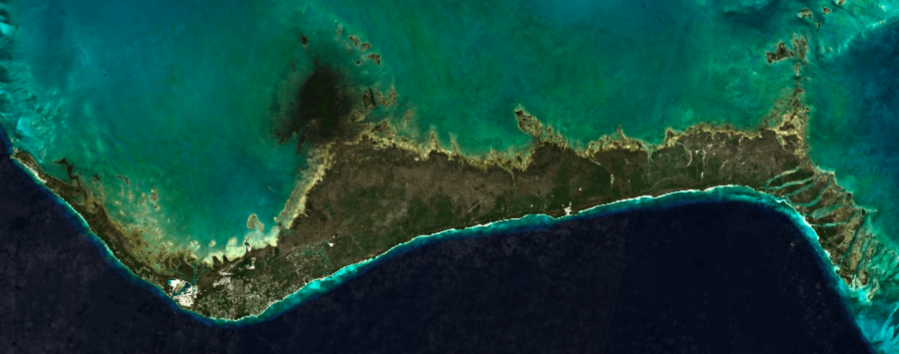
These two Sentinel-2 satellite images illustrate just how dramatically Hurricane
Dorian transformed vegetated landscapes on Grand Bahama. In the “before” image (left), the island is
covered in the verdant green of healthy mangrove forests, coppice forests, and pine forests. In the
“after” image (right), most of the island is denuded and brown. Some forested areas were only
defoliated by the storm, meaning that they temporarily lost their leaves but did not sustain any
long-term damage. However, many more areas suffered complete destruction or long-term damage,
especially on the eastern two-thirds of the island. In this photo essay, I “zoom in” on areas that
exemplify both levels of severity to compare their impacts and recovery trajectories.
This photo shows dead mangroves as far as the eye can see in one location along the
northern coast of Grand Bahama. While many mangroves were killed by Dorian’s 185-mph winds and
20-foot storm surge, many were also killed by the flooding that occurred while the hurricane sat
over the island for more than 40 hours (Cerrai et al. 2020). Mangroves are uniquely adapted to the
periodic and/or partial submersion that comes with living in the intertidal zone and are therefore
more tolerant of saltwater than most terrestrial plant species. However, even mangroves cannot
survive complete, prolonged submersion.
The hurricane dramatically reshaped portions of Grand Bahama’s coastline, like this
segment of Gold Rock Beach at Lucayan National Park. The inlet in the foreground of this photo was
sandy beach before it was washed away during the storm. The storm also destroyed much of the Park’s
coppice forest, as depicted in the background of the photo. “Coppice” is the Bahamian term for
several sub-categories of dry broadleaf forests found throughout the country, and should not be
confused with “coppicing”, the management practice of periodically cutting trees to promote new
shoot growth. Both in the Park and throughout the island, these forests provide important habitat
for many terrestrial animal species.
In addition to providing essential habitat for many marine and terrestrial animal
species, mangroves act as a “first line of defense” against hurricane winds and storm surge. They
also stabilize coastlines against both chronic erosion and acute erosion events (like the one shown
in the previous photograph). All of the mangroves in the foreground of this photo were killed by
Dorian, but their dense root network held the sediment in place and likely helped minimize the
damage to the green, living coppice forest in the background. However, dead mangroves are not as
effective as healthy ones at binding soils or absorbing storm impacts. If and when another hurricane
hits this location before the mangrove forest recovers, much of this land could be at risk of being
swept away, and inland habitats and communities could sustain even greater damages.
Grand Bahama’s pine forests, located farther inland and at higher elevations than
the island’s mangrove and coppice forests, were also severely damaged by the storm. Many pine trees
were snapped in half by Dorian’s 185-mph winds, but many more were killed by prolonged submersion in
saltwater. The pine forests of Grand Bahama and Abaco provide important habitat for many animal
species, two of which are endemic to the islands: The Bahama warbler (Setophaga flavescens)
is found
only in pine forests of Grand Bahama, Great Abaco, and Little Abaco islands. The critically
endangered Bahama nuthatch (Sitta pusilla insularis) is found only in the pine forests of
Grand
Bahama, and many conservationists are concerned that Dorian may have extinguished the species
(Sreekar et al. 2020).
Grand Bahama’s human landscapes, particularly those on the eastern side of the
island, were also dramatically affected by Hurricane Dorian. As of late February 2020, 6 months
after the storm’s landfall on the island, many homes were still severely damaged and uninhabited,
with many families living in tents and other temporary shelters.
Cleanup efforts were also ongoing, with piles of rubble and damaged cars a common
sight on the island’s east side. Abandoned cars and other debris introduce oil, plastics, heavy
metals, and other pollutants to the island’s natural environments (Nwachukwu et al. 2013), further
complicating the recovery process.
Recovery efforts have been hampered substantially by widespread damage to Grand
Bahama’s infrastructure and utilities networks. As of February 2020, much of the eastern portion of
Grand Bahama was still without power. Downed power lines like this one were very common sights along
the Grand Bahama Highway, the main, two-lane road that runs the length of the island.
Flood waters scoured away much of the foundation of this bridge, making it one of
several still closed for repairs as of February 2020. Infrastructure damages have further impeded
recovery efforts by making it more difficult to get equipment and supplies to the communities that
need them.
Freeport, Grand Bahama’s largest city and tourism center, sustained less widespread
structural damage than the island’s eastern end. Most hotels, restaurants, and gift shops were back
open for busines as of February 2020. However, many locations, like this beachfront property, were
still shuttered. Tourism income accounts for 50 percent of the Bahamas’ GDP, and Grand Bahama and
the Abaco Islands are two of the nation’s three most popular tourism destinations (Bahamas
Investment Authority 2020; Deopersad et al. 2020) The islands’ coastal landscapes are central to
many of their most popular tourist activities like fishing, snorkeling, and diving. The hurricane’s
disruption to tourism activity is estimated to have caused tourism income losses of more than $325
million USD for the Bahamas as a whole, including more than $28 million USD on Grand Bahama and more
than $270 million on the Abaco Islands (IDB 2020). Downturns in international travel during the
COVID-19 pandemic have further crippled the islands’ tourism industries, with an estimated 50 to 60
percent decrease in Bahamian tourism income attributed to the pandemic (Mulder 2020).
This photo depicts one of several enormous piles of queen conch (Lobatus
gigas)
shells in McLean’s Town, the self-proclaimed “Conch Cracking Capital of the World.” Spiny lobster
(Panulirus argus) and conch were the second and sixth most valuable Bahamian commodity
exports in
2018, accounting for 14 percent and 0.8 percent of total export income for that year, respectively
(Bahamas Department of Statistics 2019). In addition to being two of Grand Bahama’s top commercial
exports, conch and lobster are also important subsistence foods for many locals. These and other
marine species of commercial and subsistence importance depend on healthy seagrass and coral reef
habitats, which in turn depend on healthy mangrove forests. With so many local livelihoods directly
and indirectly connected to mangrove forests through the tourism and fishing industries, the
recovery of these coastal landscapes will be essential to the recovery of Grand Bahama’s human
communities.
As with all natural disasters, the impacts of Hurricane Dorian were unevenly
distributed, from forest stand-scale to island-scale and everything in between. This picture shows a
mangrove forest on Grand Bahama’s southern coast with a mix of both healthy and dead mangroves. Just
as help from island, national, and international communities will be essential to the recovery of
places like McLean’s Town, the regeneration of impacted mangrove forests will depend largely upon
recruitment of seedlings from adjacent, healthy stands. However, complete recovery of
hurricane-impact mangrove forests can take 10 to 20 years (Imbert 2018; Krauss and Osland 2020) in
areas like this one that are conducive to seedling recruitment, with healthy trees intermingled with
dead ones. In mangrove forests that were totally destroyed by the hurricane, recovery may take even
longer.
Many years of recovery lie ahead, but the process had already begun in many
mangrove, coppice, and pine forested areas. This photo shows a mangrove seedling (called a
propagule) that has taken root amidst a stand of dead mangroves. Local, national, and international
organizations are also working to facilitate the recovery of these coastal landscapes. For example,
the Bonefish and Tarpon Trust (an international sportfish conservation organization based in
Florida) and the Bahamas National Trust are coordinating a mangrove restoration program that
involves the planting of propagules in strategic locations to enhance the natural regeneration
process. The mangrove maps resulting from our field work and satellite imagery analysis are helping
to identify priority areas for restoration.
Summary
As demonstrated in the preceding photos, both the human and natural landscapes of Grand Bahama and
Abaco were devastated by Hurricane Dorian. However, even before Dorian the lines between “human” and
“natural” landscapes were always porous and fuzzy. Just as the livelihoods of many human communities
are dependent upon the provisions of coastal and terrestrial ecosystems, the sustainability of these
ecosystems is directly mediated by human activity. Many people on the islands face a long, uncertain
recovery process. But one thing is for sure: the rejuvenation of Grand Bahama’s and Abaco’s natural
environments will be vital to the recuperation of its human populations.
Acknowledgments
Many thanks to Michael Steinberg for his invaluable collaboration on this project. Both this photo
essay and the broader mapping effort are joint endeavors that would not be possible without his
wisdom and exertion. Thank you to the Bonefish and Tarpon Trust (BTT) for funding this field work.
In particular, thank you to Justin Lewis, BTT’s Bahamas Initiative Manager, for sharing his boat,
his time, and his expertise with us during the field work. Thank you to Shelley Cant-Woodside,
Director of Science and Policy at Bahamas National Trust, for her assistance and insights. Last but
not least, thank you to two anonymous reviewers for their insightful comments and suggestions.
References and Further Readings
- Bahamas Department of Statistics. 2019. Foreign Trade Publication 2018. Nassau, the Bahamas:
The Government of the Bahamas. [https://www.bahamas.gov.bs/wps/wcm/connect/
c2a16645-b29a-4e87-8289-81f876b00970/Annual+Foreign+Trade+Report
+2018.pdf?MOD=AJPERES].
- Bahamas Investment Authority. 2020. Economic Environment. Nassau, the Bahamas: The
Government of the Bahamas. [https://www.bahamas.gov.bs/wps/portal/public/About%
20Us/About%20The%20Bahamas/Economic%20Environment/].
- Cerrai, D., Q. Yang, X. Shen, M. Koukoula, and E. N. Anagnostou. 2020. Brief communication:
Hurricane Dorian: automated near-real-time mapping of the “unprecedented” flooding in the
Bahamas using synthetic aperture radar. Natural Hazards and Earth System Sciences 20: 1463-1468.
- Deopersad, C., C. Persaud, Y. Chakalall, O. Bello, M. Masson, A. Perroni, D. Carrera-Marquis,
L. Fontes de Meira, C. Gonzales, L. Peralta, N. Skerette, B. Marcano, M. Pantin, G. Vivas, C.
Espiga, E. Allen, E. Ruiz, F. Ibarra, F. Espiga, M. Gonzalez, S. Marconi, and M. Nelson. 2020.
Assessment of the Effects and Impacts of Hurricane Dorian in the Bahamas. Washington, D.C.:
Inter-American Development Bank.
- Imbert, D. 2018. Hurricane disturbance and forest dynamics in east Caribbean mangroves.
Ecosphere 9 (7): e02231.
- Krauss, K. W., and M. J. Osland. 2020. Tropical cyclones and the organization of mangrove
forests: a review. Annals of Botany 125: 213-234.
- Mulder, N. 2020. The impact of the COVID-19 pandemic on the tourism sector in Latin America
and the Caribbean, and options for a sustainable and resilient recovery. International Trade
Series, No. 157, [LC/TS.2020/147]. Santiago, Chile: Economic Commission for Latin America and
the Caribbean [ECLAC].
- Nwachukwu, M. A., B. Ntesat, and F. C. Mbaneme. 2013. Assessment of direct soil pollution in
automobile junk market. Journal of Environmental Chemistry and Ecotoxicology 5 (5): 136-146.
- Sreekar, R., K. Sam, S. K. Dayananda, U. M. Goodale, S. W. Kotagama, and E. Goodale. 2020.
Endemicity and land-use type influence the abundance-range-size relationship of birds on a
tropical island. Journal of Animal Ecology. [https://doi.org/10.1111/1365-2656.13379].
- Zegarra, M. A., J. P. Schmid, L. Palomino, and B. Seminario. 2020. Impact of Hurricane Dorian
in the Bahamas: A View from the Sky. Washington, D.C.: Inter-American Development Bank.